

New radar analysis method can improve winter river safety
Rod Boyce
907-474-7185
April 12, 2024
51Ęń┴„╣┘═° researchers have developed a way to use radar to detect open water zones and other changes in AlaskaŌĆÖs frozen rivers in the early winter. The approach can be automated to provide current hazard maps and is applicable across the Arctic and sub-Arctic.
Many Alaskans, especially in rural parts of the state, use rivers as wintertime ice highways to travel between communities or for recreation, hunting and fishing. Open water zones in river ice can be dangerous.
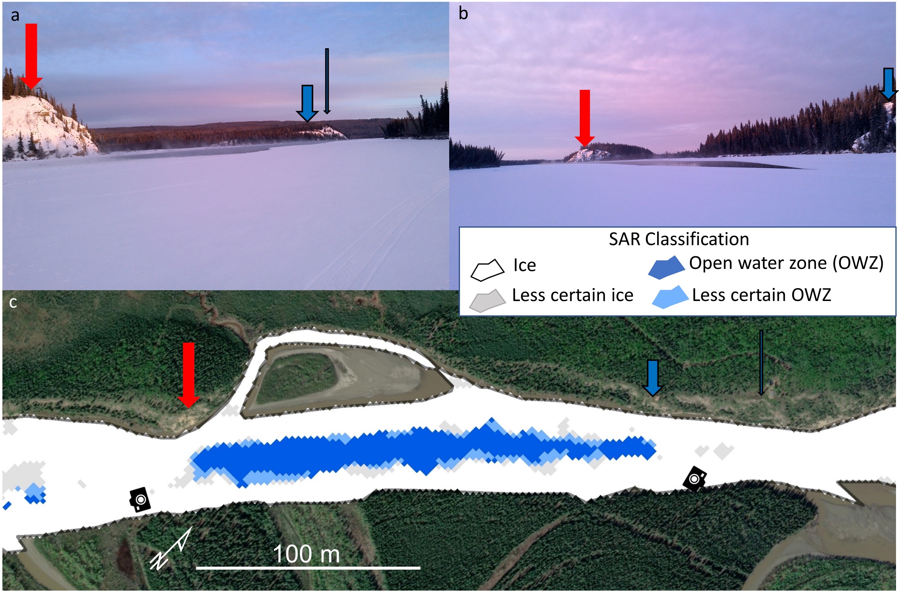
Citizen science photos (a, b) show a large open water zone on Dec. 20, 2020, on the Tanana River near Rosie Creek. The photos confirm the synthetic aperture radar classifications (c) from the same date. Red, blue and black arrows point to the same landmarks in all panels.
The new method is detailed in a paper published March 13 in the journal .
Remote sensing scientist Melanie Engram of the Water and Environmental Research Center at the 51Ęń┴„╣┘═° Institute of Northern Engineering led the research.
Co-authors include Franz Meyer of the 51Ęń┴„╣┘═° Geophysical Institute; Dana Brown, Sarah Clement and Katie Spellman of the 51Ęń┴„╣┘═° International Arctic Research Center; and Allen Bondurant, Laura Oxtoby and Christopher Arp of the Water and Environmental Research Center.
ŌĆ£Arctic warming has changed the ways rivers freeze and has impacted rural winter river travel due to later freeze-ups, mid-winter open water zones and earlier breakups,ŌĆØ the authors write.
Prior research by others focused on just one or two river reaches in Canada and temperate climates in Lithuania.
Engram and her 51Ęń┴„╣┘═° colleagues used synthetic aperture radar data from 12 reaches on eight Alaska rivers to create a river ice classification system that can be used in northern high-latitudes from October through January.
The time period concludes with January because river users have usually shared open water locations by then. River ice also becomes more complex later in the winter. Other SAR-based river ice classifications focus on spring ice during breakup.
ŌĆ£This can be customized and automated for any northern latitude rivers to provide current open water zone maps,ŌĆØ Engram said. ŌĆ£ItŌĆÖs not designed just for Alaska.ŌĆØ
Synthetic aperture radar can penetrate clouds and other atmospheric conditions such as haze, fog and rain. This is because SAR operates in the microwave portion of the electromagnetic spectrum, which has longer wavelengths than visible light.
SAR technology is widely used for environmental monitoring, agriculture, disaster management and defense.
Engram and the team refined and validated their data processing to reduce the classifications to four: ice, open water, less certain ice and less certain open water.
To do this, they worked with two types of radar data: vertical-vertical and vertical-horizontal.
For vertical-vertical, the electromagnetic wave of both the transmitted and returned radar beam has peaks and valleys, similar to the rise and fall of ocean waves.
For vertical-horizontal, the transmitted electromagnetic wave is like the ocean waves, but the wave returning from the targeted object is oriented side-to-side, similar to how a snake moves.
ThatŌĆÖs important because the different combinations can reveal different data features.
Data is also influenced by the angle at which the radar beam itself is aimed at a target. Different angles can provide different perspectives and, therefore, different information.

Panel a shows the Yukon River at Paimiut with synthetic aperture radar classifications and shore-based camera images for four dates. Panel b shows the Tanana River at Sam Charley Island, about 12 river miles southwest of Fairbanks, with shore-based camera images on top row and SAR classifications on bottom row.
Engram used data from the European Space AgencyŌĆÖs Sentinel-1 satellite. This data is archived at 51Ęń┴„╣┘═°ŌĆÖs Alaska Satellite Facility.
The researchers then compared the SAR data with aerial photos, the field of view of dozens of shore-based cameras, aerial photos, on-ice observations and reports from community members who uploaded observations to the observer portal.
ŌĆ£We had shore-based cameras all over the state, and they took a picture of the river every day,ŌĆØ Engram said. ŌĆ£And we consulted with communities, asking ŌĆśWhatŌĆÖs important to you?ŌĆÖŌĆØ
Engram chose sections of eight rivers: the Colville, Noatak, Tanana, Yukon, Kantishna, Innoko, Copper and Kuskokwim, listed here in descending order of latitude.
The team selected locations with different river volumes, widths, channel types and glacial silt content. They also chose locations in both tundra and boreal forest, as well as with variations in nearby permafrost conditions.
ŌĆ£With this ice classification, weŌĆÖre trying to distinguish between ice and open holes in the ice,ŌĆØ Engram said. ŌĆ£A lot of studies have been done, especially in Canada, looking at different types of ice. We didnŌĆÖt do that. We just went ice versus open water.ŌĆØ
The research was funded by the National Science FoundationŌĆÖs Navigating the New Arctic and Arctic Observing Network through the 51Ęń┴„╣┘═° program and by NASAŌĆÖs ROSES Citizen Science for Earth Systems Program through the Community Eyes on River Ice project.
Engram praised the Alaska Satellite Facility, which hosts the data.
ŌĆ£WeŌĆÖre really fortunate in that scientists have access to that data, not just at the 51Ęń┴„╣┘═°, but worldwide,ŌĆØ she said. ŌĆ£The Alaska Satellite Facility has made SAR data much more usable for any type of scientist. You donŌĆÖt have to be a SAR specialist.ŌĆØ
ADDITIONAL CONTACT: Melanie Engram, mjengram@alaska.edu
177-24